|
Hint
|
Answer
|
|
chain of seamounts under the ocean created by a hotspot under the Earth’s crust
|
aseismic ridge
|
|
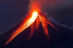
a cone shaped mountain formed out of rock or ash thrown up from inside the arth, frequently with an opening or depression at the top.
|
volcano
|
|
Two or more bodies of water meet and their waters mix.
|
confluence
|
|
a raised part of the earth’s surface with sloping sides; old mountain which because of erosion has become rounder and shorter
|
hill
|
|
dry, barren region usually sandy and without trees, little rainfall or practical use of land unless irrigated
|
desert
|
|
a curved or hooked piece of land extending into a body of water
|
cape
|
|
two separating underwater tectonic plates separating with magma expelling creating mountain ranges.
|
Ocean Range
|
|
deposits of rock and sediment left from a former or receding glacier
|
moraine
|
|
A high, steep slope of rock or soil
|
cliff
|
|
is a large crack in a glacier that can be seen from the surface.
|
crevasse
|
|
part of a body of salt water that reaches into the land; usually smaller than a gulf
|
bay
|
|
a deep area of water under the waterfall.
|
plunge pool
|
|
a broad, flat or gently rolling area; usually low in elevation.
|
plain
|
|
a narrow inlet of the sea between high banks or cliffs created by glaciers
|
fjord
|
|
All the land in each specific ocean.
|
oceanic basin
|
|
beach formation in the form of an arc with a cusp or point at each end
|
beach cups
|
|
a major bend in a river or stream
|
meander
|
|
a collapsed are, usually limestone, with exposed water.
|
cenote
|
|
a sheltered area of water where ships may anchor safely
|
harbor
|
|
a deep valley with steep rocks on each side. Also referred to as a valley or canyon.
|
gorge
|
|
part of a sea or ocean that reaches into land; usually larger than a bay.
|
gulf
|
|
an area of land that is always soaked with water; low, wet land that supports grass and trees. and S H R E K
|
swamp
|
|
a pile of sand created by wind or waves
|
dune
|
|
an elevated area of the seafloor that is higher than the surrounding area.
|
oceanic plateau
|
|
two separating tectonic plates forming a valley by the land falling.
|
rift valley
|
|
Is where two or more arêtes meet and form a pyramid shape on top of a mountain.
|
pyramidal peak
|
|
a ground depression between two faults.
|
graben
|
|
a flowing part of the river that is separated, usually by an island, and rejoins back down stream.
|
anabranch
|
|
narrow valley with steep sides; usually created by erosion
|
canyon
|
|
an island or group of island, usually in the ocean, that protects the nearby mainland coast from erosion.
|
barrier island
|
|
a group of many islands.
|
archipelago
|
|
a rock formation with steep or vertical sides and a round or dome-shaped top usually with little or no vegetation.
|
bornhardt
|
|
place where running water makes a sheer drop, usually over a cliff.
|
waterfall
|
|
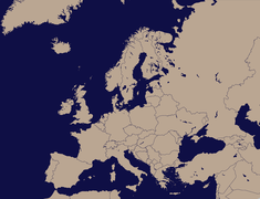
one of the seven largest bodies of land on earth
|
continent
|
|
a group sharp ridges of rocks on mountain tops usually caused by melting glaciers.
|
arete
|
|
A island, usually all rock with little vegetation, that is uninhabitable.
|
islet
|
|
land along the sea or ocean
|
coast
|
|
Rocks coming from a glacier
|
nunatak
|
|
a freshwater lake that forms behind a glacier.
|
proglacial lake
|
|
low land between hills or mountains.
|
valley
|
|
a wall built across a stream or river to hold back water
|
dam
|
|
a small body of water surrounded by land.
|
pond
|
|
a former meander of a river that has separated into a curved lake.
|
oxbow lake
|
|
an area of land completely surrounded by water
|
island
|
|
a shallow area of a river, lake or stream that has ripples caused usually by a rocky surface.
|
riffle
|
|
A irregular shaped rock formation that is tall and pillar-like
|
hoodoo
|
|
a large area of land extending into a large area of water
|
headland
|
|
piece of land that extends into a body of water and is surrounded on three sides by water.
|
peninsula
|
|
barren, battered and eroded land from water and shaped with the help of wearing and wind-driven sand and rain.
|
badland
|
|
The edge of a cliff with a steep slope
|
escarpment
|
|
land formation that occurs when sedimentary materials such as rocks, gravel, and silt, are deposited onto land as a result of decreasing or stopped water flow from a river or stream source.
|
alluvial fan
|
|
a sloping shoreline consisting of sand, gravel, soil or other sediment.
|
beach
|
|
All the water in the river exiting at a point usually into another water system like the ocean, lake or another river.
|
drainage basin
|
|
an area of sand or sentiment that has been collecting and rises above or just below the water.
|
sandbar
|
|
A river that has three or move channels that come back together or drain into the same body of water.
|
braided river
|
|
a rise in the ground or volcano caused by lava going through vents in the earth.
|
lava dome
|
|
area of land covered by lava flow.
|
lava field
|
|
a lake that is dry all year or most of the year with the dry layer being mud or salt.
|
dry lake
|
|
a flat are of land around a river that floods when the river gets high.
|
floodplain
|
|
an exposed rock range caused by erosion
|
hogback
|
|
where a river runs into the ocean or other types of salt water.
|
estuary
|
|
a cliff looking over a body of water or plain
|
bluff
|
|
a creek that is sometimes dry during the year from not having a constant water source such as rain.
|
arroyo
|
|
a land formation having a relatively flat top and steep rock walls
|
mesa
|
|
land built up by deposits of sand and silt at the mouth of some rivers
|
delta
|