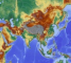
Asia has been pixelated! Only pixels with at least 50% land have survived! Each pixel can only be guessed by the country which has the most area inside it!
There are no answer boxes on purpose! The pixel grid is your only resource to name all the countries
Note: Russia has been excluded in this quiz, following JetPunk convention.
That may be, but the stans have long names! As a side note, got so stoked to see another pixelated quiz -- I know these take a lot of work so thank you thank you thank you!
Well, I knew them all so I only used time typing. I ended with 1:07 left. I think that the time could be shortened with 30 secs or so. If you know the countries, there will be no need for more time than that.
I finished with 46 seconds remaining. I didn't rush nor did get hung up. With +80% knowing the least guessed answer, I'd say this quiz is both easy and appropriately timed.
I followed the convention on the map quizzes on JetPunk which remove Russia entirely from Asia. However, rest assured once the World version is done, Russia will be included!
Great quiz, though it would do no harm to mention in the intro that you don't include Russia. Otherwise idiots like me will be on their sixth answer before they realise that their first is exlcuded and they have a huge list of answers sitting unaccepted in the text box. Lol
I think it works this way: Just to make it easy, it is decided that each country belongs to only one continent. And as it seems, in jetpunk the country belongs to the continent, where the capital city is located. Thus Russia belongs to Europe, Turkey and Kazakhstan belong to Asia. It`s not entirely logical, but it works well.
(A completely logical solution seems impossible to me, simply because the border between Europe and Asia is made up arbitrarily and far from logical).
Because the average Jetpunk user doesn't understand the concept of transcontinental countries. If you put Russia in both European and Asian quizes, you would have the comment section full of questions why it is in both. So for those challenged souls, the convention became to count transcontinental countries only to one continent. Usually the one they have the most area in, but Russia is an exeption since as people have said, the majority of the population is in Europe.
What I've seen in many quizzes is that the European part of Russia is included in Europe quizzes but not in Asian quizzes, and the Asian part of Russia is included in Asian quizzes but not in European quizzes.
So, for example, Russia is the biggest country by area in both continents, but is pretty far down the list by population in Asia.
That seems to be the best work-around for me. It does look quite strange to exclude Russia entirely from Asia.
Yep. Bangladesh is unfortunately surrounded by India which took the only 1 potential pixel for it. Turkey however is pretty close to a rectangle anyway!


Asking for a friend. Thanks.
(A completely logical solution seems impossible to me, simply because the border between Europe and Asia is made up arbitrarily and far from logical).
So, for example, Russia is the biggest country by area in both continents, but is pretty far down the list by population in Asia.
That seems to be the best work-around for me. It does look quite strange to exclude Russia entirely from Asia.
Super quiz though!